
Chapter 5 - Air Masses, Fronts and Storms
Nature Shows Its Force
Air Masses
An air mass is a large section of the lower atmosphere in which temperature and humidity are approximately the same at any given level. Air masses form when large masses of air remain stagnant over a surface, either land or water, for long periods of time. In time the mass of air takes on the characteristics of the surface it is over. If over land, the air becomes dry. Over water, it picks up moisture. If the land is cold, the air gets cold. If the land is warm, the air heats up. So the characteristics of an air mass depend on where it originates - the source region.
In order to distinguish among different air masses, the meteorologist uses a simple classification system shown in this table.
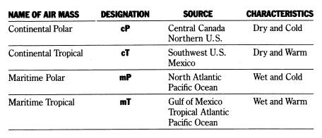
Eventually air masses move from their source regions, bringing their characteristic weather with them. Polar air masses generally move south; tropical air masses move northward and eastward. Most air masses are modified as they encounter different land surface characteristics. The degree of modification will depend on the speed at which the air mass travels as well as the nature of the surface over which the air mass moves.
What type of weather do these air masses produce?
- cP: This air mass produces weather that is cold in winter, cool in summer, with low humidity throughout the year. Cumulus-type clouds are present; yet there are often clear skies. On the leeward side of the Great Lakes and on the windward slopes of the Appalachians, snow flurries may occur. Visibility is generally quite good.
- mP: This air mass produces cool weather in summer, cold in winter, with low humidity throughout the year. The air mass is often carried long distances from the source region and may dry out when traveling over land areas. On the west coast it produces low cloudiness and fog, and sometimes, heavy rains - even snow in the higher elevations of the Rockies. As it passes over the mountains and descends into the plains, mP warms and dries and is often very pleasant by the time it reaches the east coast. When this occurs, temperatures are mild and cloudiness is at a minimum. There is also good visibility. The mP air from the Atlantic affects only the east coast. It is cold and moist in the winter, often producing layered cloudiness along with sleet or freezing rain, fog, and very cool temperatures, especially during the summer months. Visibility is generally poor.
- mT: This air mass produces very warm weather in summer, mild in winter, with high relative humidity throughout the year. It often has low clouds and fog with poor visibilities during the early morning hours, then hazy sun into the afternoon as clouds develop. Some of these cumulus clouds may build into cumulonimbus clouds, commonly known as thunderheads. This air mass brings most of the moisture into the nation.
- cT: This air mass produces warm and dry desert conditions, with good visibility. It has broad temperature ranges between night and day and generally cloudless skies.
Fronts
A front is the boundary between two air masses. The greater the difference in characteristics between the two air masses, the stronger the front. Fronts are important for two reasons. First, fronts are usually accompanied by clouds and precipitation. Second, they usually bring about a change in the weather.
There are four basic types of fronts.
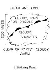
Stationary Front: With a stationary front, cloudiness is prevalent along the entire frontal boundary with most of it occurring in the cold air north of the front, where over-running is occurring. Over-running occurs when warm, moist air from the south flows northward, riding up and over the cooler, drier air north of the stationary front. This happens because cold, dry air is heavier than warm, moist air. Such conditions create not only dense cloudiness but often precipitation as well. The extent and intensity of the precipitation is dependent upon how great a temperature differential exists across the stationary front. Very cold air to the north and very warm air to the south would result in widespread and heavy precipitation. Low clouds, fog, and drizzle are common, and thunderstorms may occur if the temperature of the warm air is 60°F or higher. These conditions are found all along the stationary front. Any area in which a stationary front lies may see dreary, rainy weather for days, however, several hundred miles north or south of the front, skies are generally clear.
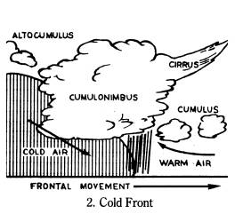
Cold Front: When the cold front begins sweeping southeastward, most of the cloudiness is thrown out ahead of the front, into the warm air. The illustration below shows a vertical profile of an advancing cold front. Note that the frontal boundary slopes to the left. As a result, the colder air at the surface leads the colder air aloft. Frontal slopes vary. The strongest cold fronts have the most perpendicular slopes. The wedge-like action of a moving cold front forces the warm, humid air in advance of the front to rise. This is the mechanism that creates cloudiness and showers in advance of a cold front. Scattered showers are common with most cold fronts, with thunderstorms limited generally to the warmer months of the year. Severe thunderstorms may develop in advance of rapidly moving or steep-sloped cold fronts, especially in very warm, humid air. These severe thunderstorms often produce hail, along with damaging surface winds sometimes in excess of 50 knots. With the strongest cold fronts - rapidly moving, steep-sloped, strong temperature differential, very warm and humid air ahead of front - tornadoes may occur.
Directly behind the cold front, winds shift to the northwest and skies are clear. If the cold front is moving rather rapidly, skies clear quickly with its passage. A slower-moving front causes cloudiness to linger.
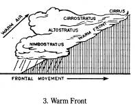
Warm Front: Cloudy, wet conditions prevail ahead - or north - of a warm front. The illustration to the left shows a vertical profile of a warm front. If the air north of the warm front is cold enough (below-freezing from cloud to ground), precipitation may be snow, then change in to sleet, freezing rain, and, finally, rain as temperatures rise above freezing closer to the warm front.
In the warm sector, between the warm and cold fronts, skies are generally partly cloudy, depending upon the moisture present in the warm air.
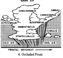
Occluded Front: Weather associated with an occluded front is similar to that of a cold front. Clouds and showers are evident ahead of the front, with clearing behind the front. A vertical profile of an occluded front is shown to the left.
Forecasting The Movement Of Lows And Fronts
There are several very important methods that may be used to forecast the movement of lows and associated fronts. Fronts are associated with and move along with highs and lows. By forecasting the movement of the pressure systems we also forecast the movements of the fronts.
Extrapolation
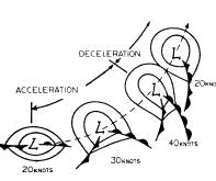
As we said earlier, extrapolation is commonly used in short-range forecasts. For example, if we know the low has moved 150 miles towards the east in the past 6 hours, chances are that if we forecast the low to continue moving in the same direction for the next 6 hours, we wouldn't be too far off. Extrapolation can also be used if the storm is taking on a curved track towards the northeast. Merely continue the trend for the low to curve more and more towards the north. This tendency for a deepening low occurs in nearly every case. At first, a weak low on what was originally a stationary front scoots eastward, or even southeastward. Then, as it intensifies, the low turns more towards the northeast, speeding up as it goes. The example to the right illustrates this effect.
As long as we know the present positions of the low and its fronts, as well as a previous position, we can use the extrapolation technique.
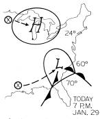
Let's assume it is January 29, 7 P.M. The weather map to the right has been plotted. We find a high centered over northern Lake Michigan with a low over the western Carolinas. How will the storm move, and how will it affect New York City?
In order to use the extrapolation technique, we take an earlier map, such as this one for 7 A. M., January 29. It shows the high over Wisconsin with the low back over Louisiana.
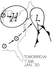
First, draw the position of the systems 12 hours ago on the 7 P.M. map. By looking at the 12-hour movement of the system, we may extrapolate for the next 12 hours, forecasting the high to move to a position near Buffalo and the low to a position southeast of Nantucket Island. We have assumed a steady movement, with no acceleration and not too much northward curvature. If these assumptions hold true, our forecast positions for January 30, as well as our weather forecast, will be accurate.
Pressure Tendency
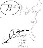
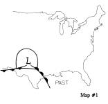
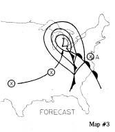
As mentioned before, the other important technique for forecasting movement of systems is by pressure tendency. A low will move toward an area of pressure falls and away from an area of pressure rises. The method of pressure tendency should be considered as superior to the extrapolation technique, as it often clues the forecaster to new trends regarding a storm's movement. For example, in Map #2, we find a developing low in western Tennessee, while in Map #1 the same low was located in the Texas panhandle. By extrapolation, we forecast the low to be near the Delaware coast in another 12 hours. This, however, would be a grave forecasting error. Because pressure tendencies now show that the greatest pressure falls are occurring, not east of the storm as the extrapolation technique would have one believe, but north of the storm in the Ohio Valley. This tells the forecaster that the storm is veering sharply to the north as shown on map #3.
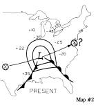
Significant pressure tendencies must never be ignored and should always take precedence over extrapolation. In terms of the forecast, an error in a situation such as the one just described could mean the difference between a little light snow over the Great Lakes (which would have been the case had the low continued eastward off the mid-Atlantic coast) and the actual forecast of heavy snow and gale force winds from Illinois across the western Great Lakes.
Storms-Mother Nature's Violent Moods:
Thunderstorms
Thunderstorms are formed when the atmosphere becomes unstable. An unstable condition develops when relatively cold air overruns relatively warm air at the surface.
Most thunderstorms observed in the United States in the course of a year are of the air mass variety. That is to say, they are formed in hot, humid air during the afternoon hours, drenching a 'relatively small area with heavy rain.
Other thunderstorms form just ahead of rapidly moving cold fronts. These are called pre-frontal thunderstorms. The most severe thunderstorms may have hail 1-inch or more in diameter along with wind gusts in excess of 70 mph. Thunderstorms also are observed with the passage of some warm fronts. However, these tend to not be as severe as the ones developed by the wedge-like action of rapidly advancing cold fronts.
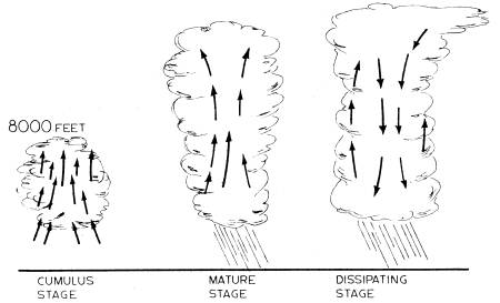
The typical thunderhead or cumulonimbus cloud takes shape when warm, rising air currents build a puffy cumulus cloud. In the cumulus stage, the cloud, as viewed from the ground, darkens, and light, showery precipitation is observed beneath the cloud. If warm air continues to feed into the cloud from the ground, it builds rapidly. Once the cloud towers above 30,000 feet or so, it is capable of producing bolts of lightning and thunder. When the cloud builds to its maximum height, it is termed "mature." At this point, it is releasing heavy precipitation, often hail, lightning, thunder, and strong wind gusts, along with severe turbulence. The storm diminishes during the dissipating stage. The three stages (cumulus, mature and dissipating) are shown below.
The lightning observed with thunderstorms is a discharge of static electricity that has built up on cloud particles. This is the result of tremendous frictional forces set up by the severe turbulence in the cumulonimbus cloud. The more severe thunderstorms exhibit violent lightning discharge, along with the resulting "sonic-boom," commonly known as thunder.
In the thunderstorm, the greatest danger is from lightning. When lightning discharges take place from the cumulonimbus cloud to the ground, the bolt of lightning often strikes the highest and most convenient point. Lightning striking a tree can cause it to disintegrate or explode. Many people are hit by lightning each year and killed.
During a thunderstorm, it is foolish not to take shelter. Head for shelter immediately if the sky appears threatening in the west, and force yourself to move even more quickly if thunder and vigorous lightning flashes are already occurring in the distance. In particular, a lake or the ocean is one of the worst places to be caught in a thunderstorm.
One simple method of calculating how far away a thunderstorm is located is to count the seconds between the lightning discharge and the audible thunder. We see the lightning flash almost instantaneously, but sound only travels at 1100 feet per second. Using this knowledge, you can take several different readings and determine how far away the storm is and whether it is coming closer or moving farther away. For example, if there is a time lag of 8 seconds between the lightning and the thunder, the distance to the cloud from where you are should be about 8,000 feet, or about 1 1/2 miles. A few minutes later, if the time lag has diminished to 4 seconds, this means the thunderstorm is less than a mile away and moving closer.
Many buildings in thunderstorm-prone open areas are equipped with lightning rods, which conduct lightning discharges directly into the ground to prevent damage. Occupants of automobiles as well as airplanes are generally safe in the vicinity of thunderstorms; yet, no pilot should ever fly into a cumulonimbus cloud where severe turbulence is prevalent since severe damage may occur, possibly causing loss of control of the aircraft.
Intense, gusty winds are associated with more severe thunderstorms. They are the result of strong downdrafts of cold air that hit the ground, often creating wind gusts of 70 mph! These winds seldom last for more than a few minutes in any one location, since they are directly associated with a certain thunderstorm often barreling along at 40-50 mph. However, just one gust of wind is enough to cause severe damage, broken tree limbs, and downed power lines, creating temporary local blackouts.
Tornadoes
Tornadoes are the most severe examples of Mother Nature's wrath currently known. Most tornadoes occur in an area having severe thunderstorms and form as a result of the tremendous instability that can be caused by warm, muggy air on the surface and very cold, dry air aloft. Most tornadoes occur just ahead of rapidly moving, strong cold fronts. Tornado-spawning grounds in the United States are the mid-west, the southern plains from Texas to Missouri, and the deep-south from Arkansas to Mississippi and Florida. This is because these areas are often affected by very warm, humid air masses, which are replaced rapidly by cold, dry air from the north and west. Most tornado activity occurs in the spring when the greatest temperature differentials are set up between the warm air flowing up from the Gulf of Mexico and the still-cold polar outbreak racing south and east from Canada. The two air masses usually involved are cP air pushing into mT air.
Tornadoes are most often sighted visually or tracked on radar. On the radar screen, a tornado appears as a "hook" in the midst of several severe thunderstorms. Winds around the center of the cyclonic whirl have been estimated as strong as 500 mph! The diameter of a tornado may vary from as little as a few hundred feet to as much as a quarter of a mile. A tornado most often begins as a funnel cloud. That is, a whirling pitch-black mass that dips out of a turbulent cumulonimbus cloud, lowering itself until it reaches the ground where it rips a path of violent destruction.
A severe tornado can completely demolish everything in its path, including steel beams and concrete. A tornado can throw a railroad car several hundred feet, pick up a house and put it down a quarter of a mile down the road. Very low pressure in the center of the tornado often creates a vacuum over the path it travels, causing houses in its way to explode. Nothing is safe, unless it is underground. If the Weather Service issues a tornado warning, this means that a tornado has been sighted in the area, and immediate shelter should be sought. Most homes and businesses in tornado-prone areas of the country provide storm cellars for protection.
Today, all severe weather forecasting - is handled nationwide by the Weather Service's Severe Weather Center located in Kansas City, Missouri. All severe thunderstorm watches as well as tornado watches and warnings are issued by Kansas City and immediately relayed to local Weather Service offices, where the information is disseminated to the public by radio and television. The art of forecasting severe weather has reached the stage today where it is quite unusual for a tornado to occur in an area that has not been placed under a tornado watch by Kansas City.
Hurricanes
The hurricane is the most severe large-scale storm we know. Its diameter may range up to a thousand miles, but most are only several hundred miles across. All hurricanes form over warm, tropical ocean water, north as well as south of the equator. In order to qualify as a hurricane, winds must be clocked at 75 mph or more. The illustration below shows a cross-sectional view of a hurricane.
A hurricane may develop from a weak, westward-moving disturbance in the trade-winds belt. These weak disturbances are known as easterly waves. Associated with easterly waves are numerous thunderstorms and gusty winds along with locally heavy downpours. Some easterly waves never intensify beyond heavy downpours, yet some, especially during the months from June through October, intensify into tropical storms. To classify as a tropical storm, winds must be greater than 40 mph. The tropical storm generally moves toward the west or northwest at about 5-15 mph. Should it continue to intensify, it may become a hurricane.
Easterly waves that make it to full hurricane intensity are of great concern to the forecaster. On the oceans, hurricane-force winds produce tremendous seas, 30-50-feet high near the storm's center, making navigation hazardous. If these tropical monsters reach land, greater problems arise. Hurricane-force winds cause widespread damage, heavy rains create flooding, and high tides associated with the advance of the hurricane are often as high as 20 feet above normal! The forecast center handling most hurricane and tropical storm forecasts is located in Miami. Tropical disturbances are tracked at sea by the use of satellite photography. As the disturbances come within range of aircraft reconnaissance, pilots actually fly a plane right into the eye of the storm. These famed Hurricane Hunters investigate the ingredients of the storm, i.e., central pressure, wind speeds, and movement. When a tropical storm comes within reach (usually 200-250 miles) of land-based weather radar, it can be tracked by the minute as it nears the coast.
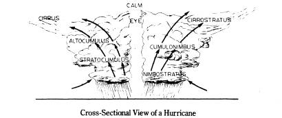
Heavy thunderstorms occur in spiral bands around the hurricane's center. Many of the thunderstorms are severe, with cloud heights in excess of 40,000 feet. In addition, tornadoes can be spawned from hurricanes, creating even more severe damage than the overall effect of hurricane-force winds, high tides, and copious rains.
The areas most affected by tropical storms and hurricanes are those coastal sections bordering on the western sides of the tropical oceans. A tropical storm may affect the Leeward Islands first, as well as those farther north in the Caribbean chain, such as the Virgin Islands, Puerto Rico, and Cuba. While some tropical storms head westward into the Gulf of Mexico and make landfall anywhere from Mexico to Florida, about half of these make a northward curve, often affecting eastern Florida and the east coast up to Cape Hatteras, North Carolina. Few manage to hit land areas north of the Virginias since they get caught in upper-level westerly winds that tend to push them out to sea into the North Atlantic shipping lanes north of Bermuda. Once they get this far north, they no longer have warm water from which to draw their energy. Then the tropical storm either dissipates or, as is most often the case, loses all tropical characteristics and becomes an extra-tropical cyclone, or a low.
Once a tropical storm makes landfall, it can no longer intensify because it has lost its source of energy - warm, ocean water. It will dissipate gradually over a 24-48 hour period, losing its ferocious winds, but heavy rains may persist and spread north and west inland, perhaps thousands of miles away from the storm's spawning grounds.
In the years ahead, research will continue in the field of tropical meteorology. Not only will emphasis be placed on forecasting the movement and intensity of these storms but also taming the violent winds. Maybe someday scientists will be able to steer hurricanes. A tall order indeed! Controlling the movement of such storms poses many problems. For example, where do you allow such a storm to strike? Do you turn a hurricane away from land areas thereby losing the valuable water that such a storm drops? Many legal and moral questions arise. So far though, we have not had to face these problems as Mother Nature has kept her secrets well protected.