
Chapter 4 - Moisture
The availability of water vapor in air is probably the single most important factor in weather. Development of all clouds and precipitation depends on the moisture content of the air. Will it rain? Will it snow? When? How much? Will the roads become slippery? These are common questions on the minds of everybody.
Moisture: An Important Ingredient Of Weather
Transpiration, Evaporation, And Evaporational Cooling
Moisture gets into our atmosphere through the process of evaporation from bodies of water and transpiration from vegetation. Transpiration is a process whereby moisture is evaporated from the undersides of plant leaves into the surrounding air.
However, evaporation from the oceans is the major source of moisture in our atmosphere. In our atmosphere, water constantly changes its state through evaporation. Evaporation is the process whereby liquid water is converted into water vapor. Evaporation is often referred to as a cooling process.
Since all moisture sources are located at the earth's surface, it follows that the atmosphere's moisture is concentrated in the lower troposphere, the atmosphere layer closest to the earth's surface. But water vapor in the troposphere can be transported great distances by winds before it is eventually "allowed" to drop out as liquid or solid precipitation.
In weather forecasting, evaporational cooling may mean the difference between a heavy rainstorm and a paralyzing snowstorm. Here's how it works: Sometimes snow begins to fall when surface temperatures are as high as 40°F or more. Upon reaching the ground, the snowflakes immediately melt. However, after an hour or so, snow may begin to "stick" on the grass and then slowly spread to the edge of roads and sidewalks. The falling snow continues to cover all surfaces and, depending on the duration of the snowfall, a storm that started out as wet and slushy now poses a threat of heavy snow accumulations. By this time, temperature readings may have dropped to 32°F or below. This drop is the result of evaporational cooling. As the snow began to fall into relatively dry air, some of the flakes "evaporated," thus cooling the surrounding air. This evaporation and cooling process will continue until the air becomes saturated, or full of moisture. At that time, the temperature will cease to drop.
It is possible to determine whether falling snowflakes will create either a wet or white "happening." When the snow begins to fall, place a wet cloth around the bulb of a thermometer and put the thermometer in an exposed area outdoors. Water molecules will begin to evaporate, lowering the temperature of the wetted bulb. This evaporation and cooling will continue until no more evaporation takes place from the wet-bulb thermometer. The air is saturated at this temperature. Hence, no more cooling can occur. At this point, the temperature of the wetted thermometer is known as the wet-bulb temperature. The temperature of the air will be the same as this wet-bulb temperature a short time after the onset of the snow. If the wet-bulb temperature is at or below 32°F, expect the snow to stick eventually, even though it may not do so at first.
Forecast hint: if the wet-bulb temperature is 32°f or below, expect falling snow to stick eventually.
Condensation
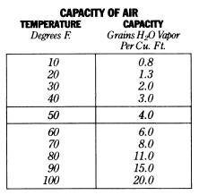
In order to fully understand a process called condensation, several terms must first be discussed. (Condensation is the process whereby water vapor is changed back to liquid water.) The first term is capacity. The capacity of air is the amount of water vapor that it is capable of holding. This depends only on the temperature of the air. The warmer air is, the greater its capacity. The following chart lists some temperatures along with the capacity of the air at that temperature.
Another term is absolute humidity. The amount of water vapor present in the air at any one time is called the absolute humidity. When the absolute humidity is equal to the capacity, the air is saturated. For example, if the air temperature is 50°F it is capable of holding 4.0 grains of water vapor per cubic foot. If the amount of water vapor present at this time is 4.0 grains of water vapor per cubic foot, the air is holding all that it is capable of holding and, therefore, is saturated.
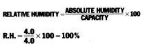
The relative humidity, which is the amount of water vapor in the air as compared to what it can possibly hold, is 100%. This is determined by the following formula:
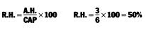
If the temperature of the air is 60°F and the absolute humidity is 3.0 grains of water vapor per cubic foot, the relative humidity would be 50%. Since air at 60°F is capable of holding 6.0 grains of water vapor per cubic foot, in this case it is holding only one-half that amount.
The temperature at which air becomes saturated is known as the dew point. If the air temperature cools to the dew point, any further cooling will cause the air to release all the water vapor in excess of its capacity, and condensation occurs.
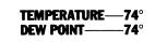
Dew point is a true measure of moisture in the air. High dew point temperature indicates an abundance of water vapor in the air, while low dew point readings indicate dry air. On a weather map, the dew point temperature is indicated near the station as follows:
When the dew point temperature approaches the air temperature, the relative humidity is high. When the dew point temperature reads the same as the air temperature, as in this case above, the relative humidity is 100%.
Forecast hint: minimum temperatures rarely go below the dew point temperature observed at sunset. (When condensation begins, heat is released and warms the atmosphere, preventing temperatures from falling further.)
Dew And Frost
The dew point temperature is extremely important when forecasting the formation of dew and frost.
Dew is made up of tiny droplets of water that form on blades of grass, cars, ground, or on any surface that has cooled below the dew point temperature of the air.
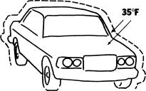
The air temperature on the night this car was parked was 42°F, and the dew point temperature of the air was 38°F. Since the air temperature was not at the dew point, condensation did not occur. However, solid objects, such as cars, grass etc., cool more rapidly than the air. By night, the temperature of the car was much lower than the temperature of the surrounding air. If the air remained in contact with the cold car for any length of time, and this could have occurred if there was little or no wind, the temperature of the layer of air surrounding the car would drop to the temperature of the car, 35°F. Since the dew point of the air was 38°F, the air temperature dropped "below the dew point," and the water vapor in the air condensed on the surface of the car. However, only the water vapor in the thin layer of air surrounding the car condensed into droplets that clung to the car's surface.
Frost forms in the same way as dew. The only difference is that the dew point temperature must be below 32°F.
Dew and frost form on nights that are clear and calm. This is true because clouds act as a blanket. Cooling would be prevented, so the dew point would not be reached. Wind would keep the air in motion, not allowing air molecules to remain in contact with the solid object long enough to cool. Dew and frost "disappear" when the sun heats the water droplets sufficiently to evaporate them.
Forecast hint: expect dew or frost to form at night when a high-pressure system is centered directly over the area.
Fog
Although the formation of fog is similar to the formation of dew and frost, there is one major difference. Dew and frost form when the temperature of the air immediately adjacent to a cold surface drops "below the dew point." On the other hand, fog forms when the temperature of an entire layer of air drops below the dew point, and water vapor throughout this layer condenses into tiny water droplets.
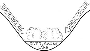
The most common type of fog is radiation fog. It forms when the skies at night are clear and the ground rapidly loses heat by the process of radiation. Air, in contact with this cold ground, cools rapidly and temperatures drop "below the dew point." Radiation fogs (also called ground fogs) are most common in valleys, not only because cold air tends to settle in valleys but also because streams and ponds are often found there. These can add water vapor to the air, raising the dew point. As the morning sun begins to heat the air, the fog "burns" away.
Forecasting Fog
Several factors must be considered when making a fog forecast. First, how much moisture is present in the air? (The dew point temperature indicates the moisture content.) Second, how much cooling will occur in the air? Generally, if the air temperature and dew point temperature are within 5°F at sunset and the skies are clear, the formation of radiation fog is probable.
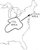
Weather maps also can aid in making a fog forecast. For example, if weather systems are moving from west to east on a particular day, and your local area is in the east, a glance at fog conditions to the west can be helpful. If visibilities are greatly restricted to the west, and you expect that "parcel of weather" to be in your area during the early morning hours, it is likely that local visibilities will be restricted by fog.
Clouds
Clouds are formed when air is cooled, condensing the water vapor already present in the air into tiny water droplets. Generally, the mechanism responsible for cooling the air and forming clouds is rising parcels of air. The manner in which the air rises determines the cloud formation. Air can rise vertically or at a slant. Parcels of air that rise fairly rapidly in the vertical, form cumuliform clouds, clouds showing extensive vertical development. Air parcels rising rather slowly and obliquely form stratiform clouds.
Clouds on Weather Maps
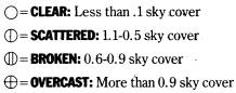
The amount of clouds in the sky over a particular station is indicated in the station model for the airport.
Naming Clouds
There are three basic cloud types, cirrus, cumulus, and stratus. All other clouds are derived from these; thus it is important to know their characteristics.
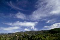
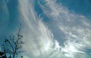
Cirrus Clouds
High, thin, wispy clouds composed of ice crystals. They are found most often at elevations of 25,000-35,000 feet. The names of all high clouds contain the word CIRRUS.
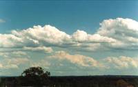
Cumulus Clouds
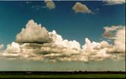
White, puffy masses. These clouds are formed from rapidly rising air currents and, thus, exhibit extensive vertical development. Under normal conditions they have flat bases and rounded tops.
Stratus Clouds
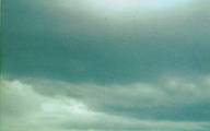
Low clouds, forming a blanket-like layer in the sky.
By combining these cloud names and characteristics, a new cloud is named, possessing the characteristics of both parent clouds. For example, cirrostratus clouds are high clouds, composed of ice crystals. However, they are lower than cirrus and generally cover the sky in sheet-like fashion.
Two other words must be introduced in order to complete the cloud story. Alto means high, but not as high as cirrus and nimbus generally means precipitation. If you combine these words with the name of a parent cloud, you can name a new cloud.
From all of this information, we can list the names and characteristics of cloud types as well as the weather commonly associated with them. Of course, variations in the described weather are possible.
High Cloud Family: (20,000-30,000 Feet)
CIRRUS
They are the highest clouds in the sky. They are composed of ice crystals.
Phenomena: They usually bring fair weather for 36 hours. However, if they thicken in the southwest and become lower, forming cirrostratus clouds, they could foretell rain or snow in 12-24 hours, especially if the surface winds are blowing from the northeast, east, or southeast.
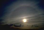
CIRROSTRATUS
These clouds appear as a thin, whitish veil or tangled web in the sky. They are composed of ice crystals.
Phenomena: They produce the halo or ring around the sun or moon. They foretell rain or snow in 12-24 hours. However, if the surface winds are from the southwest, cirrostratus clouds usually mean cloudy, warmer weather.

CIRROCUMULUS
These clouds are patches of small globular ice crystals that often look like rippled sand (small, white puffs, flakes, or streaks).
Phenomena: Precipitation is possible in 12-24 hours if the surface winds are blowing from the northeast, east, or southeast.
Middle Cloud Family: (6,500-20,000 Feet)
STRATUS
These form a low gray, uniform layer, resembling fog but not resting on the ground.
Phenomena: They are often associated with drizzle.
ALTOSTRATUS
These clouds that look like a fibrous veil or sheet, gray or bluish in color. The sun or moon is visible through them but they appear as if seen through frosted glass.
Phenomena: If surface winds are from the northeast, east, or southeast, these clouds foretell rain or snow. (Snow or rain generally begins 2-4 hours after the sun or moon disappears completely behind the clouds.) If the surface winds are from the southwest, expect continued cloudy, but milder weather.

ALTOCUMULUS
These are separate little, white or gray rounded "packs of wool." They are not as high as cirrocumulus, thus, "packs of wool" appear larger because they are closer to the ground.
Phenomena: A "mackerel" sky sometimes foretells oncoming precipitation in 12-24 hours if the surface winds are blowing from the northeast, east or southeast.
STRATOCUMULUS
These are long, parallel, gray or whitish rolls of globular masses, often covering the entire sky. Many times they follow the passage of a cold front and may appear more threatening than the weather they produce.
Phenomena: They often indicate strong winds and turbulence.
NIMBOSTRATUS
These are low, gray stratus clouds.
Phenomena: This cloud formation usually produces long, steady, periods of rain or snow. It is a chief precipitation producer.
Clouds Of Vertical Development: (1,500-50,000 Feet)
CUMULUS
These appear as puffs of cotton, usually in the afternoon.
Phenomena: Generally they indicate fair weather for 24-36 hours. However, if they grow larger and larger, forming cumulonimbus, thunderstorms can be expected during the next several hours.
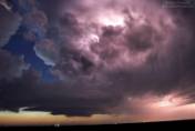
CUMULONIMBUS
(Thunderhead) These are towering clouds that develop from simple, cumulus clouds.
Phenomena: They indicate strong convection with violent up and down drafts. They are often associated with heavy rain showers and even hail, lightning, thunder, and strong winds.
Precipitation
Precipitation is the process whereby moisture, in the form of cloud droplets, reaches the ground. The first step in obtaining precipitation is to cool a parcel of air to the dew point. This cooling, necessary for the eventual formation of water droplets or ice crystals, occurs in two ways.
As we said earlier, the first mechanism, and by far the most important one, is cooling brought about by rising parcels of air. As a parcel of air rises, it reaches levels where the surrounding air pressure is lower. This allows the parcel of rising air to expand. Any gas that is allowed to expand will cool. This adiabatic cooling condenses the water vapor in the rising air into tiny water droplets, forming a cloud.

As air is forced to rise (known as lifting) over a mountain range, clouds tend to form on the windward slopes. Water droplets in the clouds often cling together around microscopic impurities (such as a grain of dust) in the cloud and eventually get heavy enough to fall as a drop.
However, on the leeward side of the mountain, the air descends and is warmed by compression. This warming dries parcels of air descending the leeward slopes, creating cloudless skies on the leeward side of high mountains. As the parcels of air reach the valley floor, they are warm and dry, thus, creating a desert climate on the lee of high mountain ranges. Death Valley is a perfect example of this phenomenon.
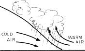
Precipitation is very common along fronts (cold, warm, stationary, and occluded). Warm air is forced to rise over cold air near the ground. The intensity and amount of precipitation depends on the moisture available in the air as well as the extent to which the air is lifted and subsequently cooled.
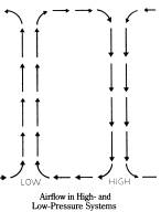
Excessive and often heavy precipitation occurs in low-pressure systems. Obviously, air must be rising somehow. A cross-sectional view of a low-pressure system shows that low-pressure causes air to flow into the center of a low near the ground, and then upwards, creating rising parcels of air and subsequent cloudiness and precipitation. In a high-pressure system, the opposite effect takes place. Air flows out of the center of the high near the ground, allowing air to descend from higher altitudes. Since descending air dries, skies are nearly cloudless in a high-pressure system.
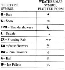
Types of Precipitation
There are five basic forms of precipitation - rain, snow, sleet (ice pellets), freezing rain, and hail.
Rain is described as drops of water falling from the clouds, at least a few thousand feet above the ground. Very fine drops, called drizzle, fall from lower clouds such as stratus clouds. The classic snowflake consists of a six-sided crystal. At very low temperatures, snow may take the form of ice needles. Sleet or ice pellets are formed when raindrops fall through below-freezing layers of air, solidifying into pellets of clear ice. Freezing rain forms when drops of rain come in contact with below-freezing surfaces on the ground. This condition, if prolonged, may create an ice storm, causing hazardous driving conditions along with severe damage to trees, shrubs, and telephone and electric wires. Finally, hail can be described as alternating layers of snow and ice that resemble an onion in structure. Hailstones, oddly enough, are usually associated with severe summer thunderstorms and are rarely experienced during the winter. Severe thunderstorms are rare during winter because the air is not warm enough to support the very strong updrafts necessary.
The type of precipitation that strikes the ground depends on the vertical and thermal structure of the atmosphere. Following is a diagram depicting the varying vertical conditions that form the different types of precipitation.
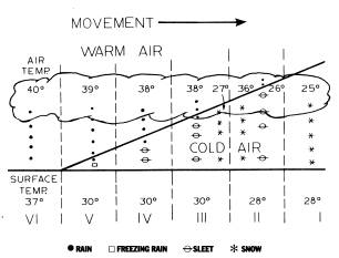
Notice that the atmosphere is divided vertically into cold air at the bottom and warm air on the top (Temperature Inversion). The diagram is also divided into six areas:
Area Ⅰ: The clouds are located completely in the cold air (below 32°F). Since the temperature of the dew point is below freezing, snow forms. As it falls through the air and hits the ground, it does not melt, since the ground temperature is also below freezing. In this case, the snow "sticks."
Area Ⅱ: The clouds are located in both the cold air (below 32°F) and warm air (above 32°F). Raindrops are formed. However, as these raindrops in the warm air fall into the colder air below, they eventually freeze and form solid pellets of ice that we call sleet or ice pellets. These pellets reach the ground as sleet, which some people mistakenly call hail. Notice also that a large portion of the cloud is located in the cold air. Since the temperature is below 32°F, snowflakes are formed and fall to the ground and stick. Therefore in area II, a mixture of snow and sleet is falling.
Area Ⅲ: This area is similar to area II except that a greater portion of the cloud exists in the warm air. The greater proportion of the precipitation would be ice pellets rather than snowflakes.
Area Ⅳ: The entire cloud exists in the above-freezing warm air. It is no longer possible to have snowflakes falling. However, since the air near the surface is below 32°F, sleet still is the form of precipitation reaching the ground.
Area Ⅴ: Again, the entire cloud is located in the warm air. Therefore, raindrops are formed. However, examine the depth of the cold air in area IV compared to area V. The cold air is much "deeper" in area IV. A raindrop has sufficient time to freeze as it falls through the cold air in area IV, but since the cold air is so shallow in area V, the raindrop passes through it before turning into a pellet of ice. Therefore, it strikes the ground as a raindrop. However, since the ground temperature in area V is 30°F, the rain freezes on contact with the ground, forming freezing rain or glaze.
Area Ⅵ: The entire cloud is located in the warm air. This causes raindrops to form. Since the surface temperature is above freezing, "ordinary" rain hits the ground.
The movement of the weather system shown is from left to right. If you were located at a station in area I, it would be snowing. As the entire weather system moves over, the snow would become mixed with sleet (area II), would become almost entirely sleet (area III), would eventually turn to all sleet (area IV). The precipitation would then change to freezing rain (area V) and finally to rain in area VI. Remember the sequence - it is very important! Snow, to sleet, to freezing rain, to rain. This diagram represents precipitation associated with the passage of a typical winter warm front.
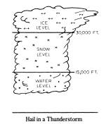
As we said earlier, hail is formed only in thunderstorms. In these storms, shown above, strong updrafts and downdrafts of air occur. A raindrop is carried from the water level to the snow level by an updraft. Here the raindrop freezes, forming a pellet of ice, which at this moment is sleet. However, the updraft carries it further up in the cloud to the ice level. Downdrafts of air then carry this growing piece of ice to the bottom of the cloud (water level). If the updrafts are strong enough, the up-and-down journey repeats itself. In violent thunderstorms, strong updrafts may repeatedly throw the hailstone into the higher reaches of the cloud. Each trip adds another layer of snow and ice to the stone, causing it to grow larger and larger. Finally, when the updrafts can no longer support the weight of the hailstone, it falls to the ground.
During very severe storms, hailstones have been found to have circumferences of up to 10-15 inches, weighing as much as 1 1/2 pounds. However, on a hot day in September; 1970, in Coffeyville, Kansas, hailstones 17.5 inches in circumference, weighing 1.67 pounds each were recovered. They were immediately crushed, made into snow cones, and enjoyed by the residents of Coffeyville.
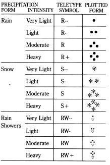

If a station were reporting heavy snow showers, for example, it would be indicated on the station model as follows:
Forecasting Accumulations Of Snow
As a snowstorm approaches an area, expected snow depths can be forecast by examining the station models for the areas that will affect the region. The following intensities will produce the indicated snowfalls.
- Very light snow (S--) 1" of snow accumulates every 6-12 hours.
- Light snow (S-) 1" of snow accumulates every 2-3 hours.
- Moderate snow (S) 1" of snow accumulates every 11/2 hours.
- Heavy snow (S+) Over 1" of snow accumulates per hour.
With heavy snow it is possible to accumulate 2-3 inches of snow per hour. By calculating how long it will snow and how hard it will snow, it is possible to determine how many inches of snow will accumulate.
Forecasting Snow Vs. Rain
Perhaps one of the most exciting and challenging aspects of weather forecasting is determining what form winter precipitation will take. If the public is told to expect rain, and heavy snow falls instead, mammoth traffic tie-ups and other snow-related problems crop up. However, if snow is forecast and it rains instead, millions of dollars may be spent on unnecessary precautions. Here are some important parameters to aid the forecaster in determining the type of precipitation that will occur.
Storm Movement
The exact movement of the storm system, as well as the locations of other pressure systems, are major concerns in determining which form of precipitation will fall.
In essence, these rules apply for all areas of the country. Storms passing over or to the west of a certain location usually bring rain to that area. Storms traveling just east or south of an area are potential snow "dumpers." Storms too far to the east usually pose no threat of heavy snow. Several examples will illustrate these rules. In each case, a storm develops and moves along the east coast.
Case A
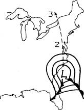
A developing Carolina storm begins moving northward. In the New York City area, winds will become easterly and increase in speed. During the winter season, coastal waters are relatively warm. As a result, winds blowing from these waters will have a warming effect on the lower atmosphere along the immediate coastline. In this case, rain or snow will begin in New York City, depending on present temperature conditions. As the storm reaches point "2", winds in the New York City area will be southeasterly. A southerly component enhances the inflow of warmer air from the south into the area. If the precipitation from the storm did begin as snow in New York City, it would quickly change to rain as the center of the storm passed to the west of the city. Southerly winds would prevail in the New York City area as the storm reached point "2", completely negating the possibility of significant snowfall for the area and creating a nearly all-rain situation.
Case B
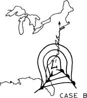
Case "B" shows the Carolina storm passing directly over the New York City area. Again, as in Case "A", snow or rain may fall at the outset of the storm, but as the storm approaches the region precipitation will change to rain.
This is because of the warming effect of easterly winds and the fact that the storm center itself is composed primarily of warm air.
Case C
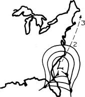
Case "C" is the "ideal" storm track for heavy snow in the New York City area. The Carolina storm moves northeastward along the coast. Precipitation generally starts in the form of snow as northeasterly surface winds pump cold enough air into the New York City area. As the storm reaches point "2", northeasterly winds continue and so does the snow. In fact, it is at this point that the snowfall often becomes heavy in the New York City area since moisture is usually most abundant just in advance of the center of the storm. When the storm reaches point "3", the winds will change back to northwesterly in New York City. The northerly component pulls down colder, yet drier air, bringing an end to the steady snow. Later, a more westerly component strengthens the drying trend and the skies begin to clear.
Case D
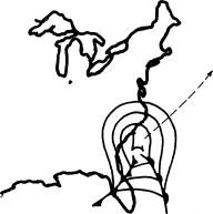
Case "D" produces no significant snow in the New York City area. Here, the storm system and its precipitation shield pass too far to the east of the city. Northwesterly winds pull cold dry air into the area. There may be a few snow flurries however, as colder, less stable air invades the city.
In critical snow-versus-rain situations, elevation above sea level is often the difference between a heavy rainstorm and a paralyzing snowstorm. So, nearness to the ocean and elevation are important factors to consider when making a snow-versus-rain forecast. Generally, the surface temperature that separates rain from snow is 35°F.
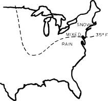
In the immediate vicinity of the above rain-snow line, more often than not, the precipitation will be mixed. On the cold side of the line, precipitation will be in the form of snow, while on the warm side, it will be in the form of rain rain.